
New Study Reveals Ancient Doggerland Landscape Started Sinking 10,000 Years Ago
Researchers have uncovered new evidence that reveals how Doggerland – the enormous prehistoric landscape that once connected Europe to Britain – was gradually overwhelmed by rising sea levels at the end of the last Ice Age. This is the latest Doggerland research paper to be published by scientists from the University of Bradford. Carbon dating of core samples taken from the North Sea suggest sea levels began to rise approximately 10,000 years ago.
The study, published this week in the academic journal “Humans”, uses detailed geochemical analysis of sediment from a core sample from the southern North Sea to reconstruct the final environmental stages that led to Doggerland’s disappearance as sea levels rose.
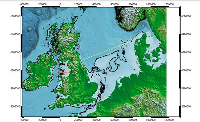
A digital map showing the location of Doggerland. Archaeologists are learning more about ancient sea level changes. Picture credit: University of Bradford.
Picture credit: University of Bradford
Lead author of the study Dr Mohammed Bensharada (University of Bradford) explained:
“Tracing organic residues and inorganic compounds within cored sediment, linking them to their origins, and then reconstructing a whole environmental picture around them, felt like solving a puzzle. Cored sediment provided a continuous archive of events, moving from one environment to the other, providing information about the missing land and the sea rising. We all know that Doggerland lies beneath the North Sea, but still the question; how much do we actually know about this mysterious place? This paper demonstrates the power of science by combining the capability of analytical and geochemistry with archaeology, detailing the final stage of Doggerland appearance.”
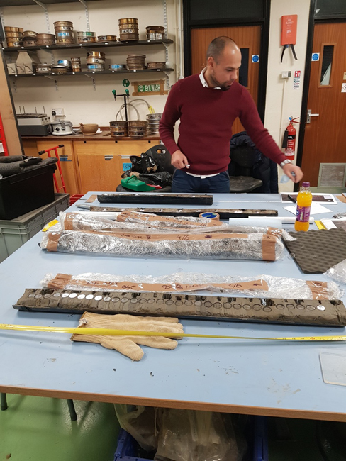
Lead author of the Doggerland research Dr Mohammed Bensharada examines a series of core samples. Picture credit: University of Bradford.
Picture credit: University of Bradford
Latest Doggerland Research Maps Out Final Stages of the Landmass
The leader of the University of Bradford’s pioneering Submerged Landscape Research Unit, Professor Gaffney commented that the findings provide one of the clearest environmental timelines yet for the final stages of Doggerland’s existence.
The professor stated:
“Doggerland wasn’t lost in a single moment of drama. What we’re seeing here is a long, complex process of environmental change that would have unfolded over generations, repeatedly transforming how people lived in this landscape. By combining archaeology with high resolution geochemical science, we can now tell a much more detailed story about how Europe’s largest prehistoric landscape was gradually claimed by the sea.”
Taking a Multi-disciplinary Approach
Professor Gaffney said the team analysed a shallow sediment core recovered from Doggerland, applying a “multiple proxy” approach that combined thermal measurements, organic biomarkers, radiocarbon dating and chemostratigraphy. Together, these techniques allowed the researchers to track subtle but critical shifts in vegetation, water conditions and sediment sources over time.
The results reveal a complex and gradual transformation, moving from freshwater and terrestrial environments to increasingly saline, marine conditions during the early Holocene. Radiocarbon dating of organic material pinpoints a key transition to between 10,243 and 10,199 years ago, when rising sea levels began to dominate the landscape.
Analysing Chemical Signatures
Significantly, the research demonstrates that Doggerland was not lost in a single catastrophic event, but through a progressive process of inundation that would have repeatedly reshaped the lives and movements of the people who lived there.
Geochemical work was led by Dr Mohammed Bensharada and Dr Alex Finlay, supervised by Professor Richard Telford and Dr Ben Stern, whose analysis focused on microscopic particles and organic residues preserved within the core samples.
By identifying chemical “signatures” linked to freshwater plants, terrestrial soils and marine inputs, the team reconstructed changing environmental conditions with exceptional precision.
The research demonstrates how sophisticated laboratory techniques can unlock new archaeological insights from landscapes that are now completely submerged. It also strengthens the case for Doggerland as a dynamic, lived in environment that responded gradually to climate change rather than disappearing overnight.
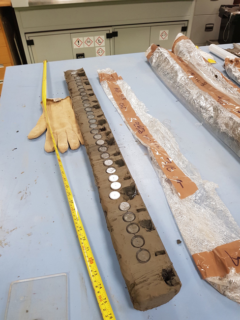
Core samples taken from under the North Sea, which revealed evidence of trees and plants, indicating the land was above sea level around 10,000 years ago. Picture credit: University of Bradford.
Picture credit: University of Bradford
Important Implications for Climate Change Studies
Learning about the past helps scientists to study the present. The Doggerland research can be applied to other submerged prehistoric landscapes elsewhere in the world. In addition, it can help us to understand how modern-day communities adapt to rising sea levels. As sea levels rise today so, this type of research becomes increasingly relevant.
Mike from Everything Dinosaur commented:
“Learning about ancient prehistoric landscapes can help us understand the likely consequences of climate change.”
For prehistoric animal models and figures: Prehistoric Animal Figures.