
Exploring the Geology of Cheshire – Alderley Edge
Exploring the Geology of Cheshire – Trip to Alderley Edge
Just a few miles from our warehouse the Cheshire plain ends and gives way to a huge sandstone ridge that rises to something like 190 metres above sea level. This is the famous sandstone landscape of Alderley Edge, a place where legends of wizards, witches and warlocks are abundant, but unfortunately fossils are very rare indeed.
However, feeling the need for a bracing walk and wanting to get out of the warehouse and office for a few hours on a Saturday afternoon, a couple of Everything Dinosaur team members took the opportunity to visit the this National Trust site and do a little exploring. Although this site is owned by the National Trust, much of the sandstone outcrop is classified as a Site of Special Scientific Interest (SSSI) and indeed, the rock formations in the area have been designated RIGS – Regional Important Geological Sites.
The sandstone was laid down as sedimentary rock under the action of wind and water deposition during the Triassic period (approximately 230-240 million years ago). A number of beds are visible in the area, the sediment of the beds vary in terms of composition, hardness, size of sand grains and their colouration. During this part of the Triassic period, Cheshire was much closer to the Equator than it is today. It made up part of the super-continent Pangea, the northern part, known as Laurentia, land that would eventually form the Americas and Europe. To the east there were salt marshes and ultimately shallow seas forming the mighty Tethys ocean. To the west, travelling inland you would have encountered a harsh, desert environment similar to the Sahara desert in North Africa. The area was very hostile to life, being hot, dry and effectively classified as “red desert”. The lack of water and subsequently the lack of life explains the very poor fossil record for this part of Cheshire. Only a few tiny brachiopod fossils (shellfish) are associated with this part of eastern Cheshire.
The stratigraphy of the sediments, the order in which the various sediments have been deposited is quite complicated. Two main stratigraphic groups are represented, Sherwood sandstones and the more recent Mercia mudstone deposits. The oldest exposed sediments belong to the Wilmslow formation (Wilmslow is a large town in the area). A number of layers of conglomerate can be viewed at Alderley edge. These layers represent deposition of sediment by rivers. It is believed that during this time in the Triassic, this area had a number of seasonal rivers that ran in an north-westerly direction, eventually reaching the coastal salt marshes and then the sea. Occasionally, flash floods occurred and the action of water bringing sediment into the area for eventual deposition can be viewed at a number of exposed rock outcrops. For example, a layer of conglomerate deposition, lying directly above sandstone can be seen at the Church Quarry site, one of the places of interest we visited on our walk.
Close up of Conglomerate Layer (Church Quarry site)
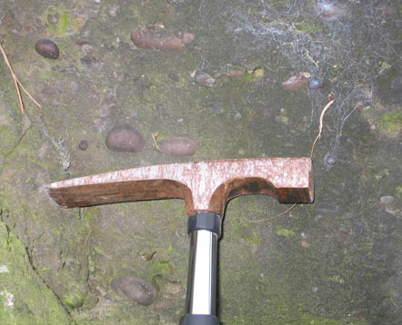
Picture credit: Everything Dinosaur
In the picture, a number of rounded, small pebbles can be seen. This is evidence of deposition by the action of water. The pebbles range in size from a few millimetres to up to 8 cm across, one of our trusty geology hammers has been placed in the picture to provide a scale. As the water lost energy, it was unable to carry so much sediment and so these pebbles were deposited to form what are termed “inclusions” within the conglomerate.
This part of Cheshire has been mined for metals such as copper, lead and iron. Archaeological evidence indicates that mining first began in this area around 4,000 years ago. As we walked towards the very edge of the sandstone ridge we encountered the Pillar and Doc mines, evidence of excavation deep into the sandstone. Looking carefully amongst the debris and scree on the steep slopes we found several examples of malachite.
The sandstone has veins of green minerals (the malachite) running through it. This is the most common ore found at the Alderley Edge site (copper carbonate hydroxide) and from this ore copper can be extracted. Malachite is formed by the reaction of water containing dissolved carbon dioxide with sulphide ores.
Some of the pieces of Malachite found near the Pillar and Doc Mines

Exploring the Geology of Cheshire. Picture credit: Everything Dinosaur.
Picture credit: Everything Dinosaur
In the picture, the green veins of malachite can be seen, we put the 20 pence piece in for scale.
Although we did deviate from the designated walk we were supposed to be on (the wizard walk), we did manage to see most of the points of interest our guide book had informed us about. The walk took about 3 hours and it was a most pleasant afternoon.
View from “the Edge” the end of the Sandstone Ridge
")
What a view! Picture credit: Everything Dinosaur.
Picture credit: Everything Dinosaur
We did make frequent stops to admire the views and examine the exposed strata, even finding a couple of thin layers of mudstone (but no fossils). The above picture is the view from the edge of the sandstone ridge looking out towards Derbyshire. On a clear day, it is possible to see the city of Manchester to the north (twenty miles away) and out over the Cheshire plain to the Derbyshire hills.
Visit Everything Dinosaur’s website: Everything Dinosaur.