
Serendipity Taken Out of Fossil Finding
Very often a major fossil find is attributed to serendipity, someone being in the right place at the right time. Even the most experienced palaeontologist needs a little bit of luck, take for example the discovery of the ancient hominin Homo floresiensis on the Indonesian island of Flores. Had the research team excavated an area just one metre either side of that part of the cave they did excavate they would never have found the beautifully preserved skull and partial skeleton of an individual (the holotype LB-1). Yes, “lady luck” does play a part in many new scientific discoveries. Palaeontologists are all too aware of serendipity.
However, an international team of scientists, including researchers from the University of Adelaide, have created a mathematical model to help palaeontologists find the remains of long-extinct animals.
Combining Scientific Disciplines to Predict Where Fossils Can be Found
The international team, that included researchers from Kiel University (Germany), as well as Australia, looked at the estimated ages of the fossils from a number of extinct Australian megafauna and plotted known fossil find locations for these creatures against data for the prehistoric climate of Australia. This provided a guide to the maximum likely ranges of the animals in the study. This information was then mapped against the geology of Australia to provide an indication of what suitably aged, likely fossil bearing strata was exposed.
Weighting for the erosion potential of the rocks was built into the mathematical model and this data set could then be used to help determine the best areas in the country to look for the animal’s fossil remains.
Scientific Paper Published
A paper detailing the research has been published in the on line journal PLOS One, the research team confidently state that their model can provide fossil hunters with guidelines on how to find fossils elsewhere in the world too.
Determining the Best Places to Hunt for Fossils
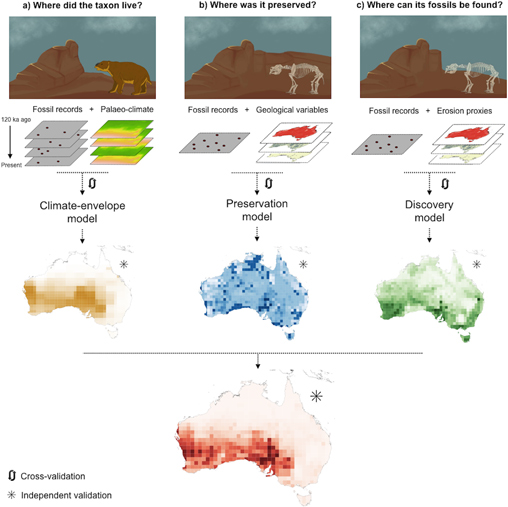
Combining palaeo-climate data with erosion studies and known fossil finds to predict where fossils can be found.
Picture credit: Sebastián Block, Frédérik Saltré, Marta Rodríguez-Rey, Damien A. Fordham, Ingmar Unkel, Corey J. A. Bradshaw
The picture above provides an illustration of how the mathematical model was constructed and how to implement it. For any given type of extinct animal (in this example, the giant marsupial Diprotodon), the red map at the bottom shows the likely places to hunt for fossils of that animal. The darker the red shading the more likely that location is to be a “fossil finding hot spot”. The red map has been created by looking at certain variables, namely:
- Where the animal used to live – a map created by assessing ancient climate data and known fossil finds (the brown map).
- Where the fossils could be preserved – using an assessment of the geology of the local area (blue map).
- The location where it is now possible to find the fossils of that particular animal, building in an assessment of erosion profiles of the likely fossil bearing strata (green map).
A Systematic Approach for Palaeontologists
The scientists are confident that this systematic approach to fossil finding is more likely to be successful than random approaches to fossil hunts, even out-doing sophisticated approaches such as using satellite data to identify likely fossil bearing outcrops and exposures.
Five genera of Late Pleistocene megafauna were selected for this study. All had an extensive and relatively widely distributed fossil record on the continent and since all had become extinct relatively recently there was plenty of evidence to support an assessment of the ancient climate. The creatures studied were Thylacoleo (the marsupial lion), Protemnodon (a giant wallaby), the cow-sized, giant marsupial Zygomaturus, the flightless bird Genyornis and Diprotodon, the largest marsupial known to science.
Diprotodon Played a Role in the Study
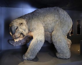
Diprotodon – A giant marsupial.
Picture credit: Australian Museum/James King
Although all these five genera are unique to Australia, the scientists had sufficient fossils to create an accurate map of the creatures prehistoric distribution.
The Reasoning Behind the Model
Commenting on the reasoning behind their model, project leader, Professor Corey Bradshaw, (Sir Hubert Wilkins Chair of Climate Change at the University of Adelaide) stated:
“A chain of ideal conditions must occur for fossils to form, which means they are extremely rare, so finding as many as possible can tell us more of what the past was like, and why certain species went extinct. Typically, however, we use haphazard ways to find fossils. Mostly people just go to excavation sites and surrounding areas where fossils have been found before. We hope our models will make it easier for palaeontologists and archaeologists to identify new fossil sites that could yield vast treasures of prehistoric information.”
Lead author of the scientific paper Sebastián Block explained that the team made use of modelling techniques already used widely in ecology. They looked at the past distribution of these prehistoric genera, where fossils were likely to have formed and the probability of making field discoveries. The model may not make the back-breaking work of excavating fossils any easier, but at least palaeontologists will be looking in the most likely places.
The Probability of Finding Fossils
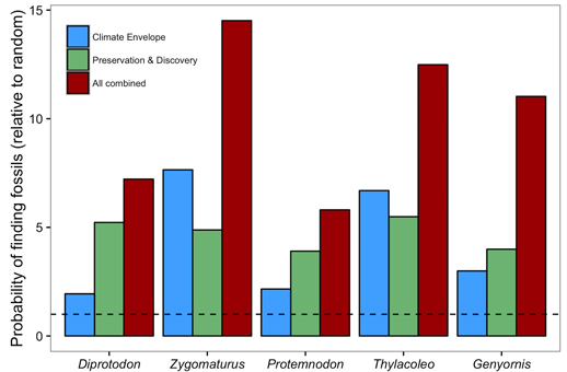
Combining disciplines increases the probability of finding fossils.
Graph credit: Sebastián Block, Frédérik Saltré, Marta Rodríguez-Rey, Damien A. Fordham, Ingmar Unkel, Corey J. A. Bradshaw
Assisting Palaeontologists and Fossil Hunters
The bar chart above shows how the model increases the likelihood of fossil discovery for the five genera studied.
The chances of finding a fossil of that particular genus compared to a random search is plotted on the vertical (Y axis). The blue bars represent the probability of finding a fossil based on an assessment of ancient climate. The green bars show the probability of a successful fossil hunt using just geological data and erosion assessments. The red bars show the increased likelihood of success after the application of the variables used in this assessment (ancient climate, preservation potential and known discoveries). The dashed line outlines the probability of finding a fossil using a random search in a known fossil bearing locality.
Likely Fossil Preservation Sites Accounted For
The team added into their data relevant predictors for the likelihood of fossil discoveries. For example, many Late Pleistocene fossils are found in caves so the number of caves in the areas studied were also plotted. In addition, as Australian megafauna (indeed most terrestrial animal fossils), are found in association with ancient lakes and rivers, areas where sedimentary material can be built up were given greater weighting as indeed were areas that tended to be more open and devoid of extensive plant cover as this would make fossil finding easier.
Using the model, likely fossil “hot spots” identified include the area south of Lake Eyre (South Australia), the land to the west of Lake Torrens (also South Australia) and the Shark Bay locality in Western Australia.
Kiel University’s Professor Ingmar Unkel added:
“Our methods predict potential fossil locations across an entire continent, which is useful to identify potential fossil areas far from already known sites. It’s a good “exploration filter”; after which remote-sensing approaches and fine-scale expert knowledge could compliment the search.”
Luck will still play a role in fossil discoveries but at least this mathematical model helps to swing the odds in the scientists favour.
Leave A Comment