International Collaboration to Pinpoint Stone Age Settlements in Doggerland
A two-year marine expedition to pinpoint the location of a prehistoric settlement in the southern North Sea will be officially launched next Tuesday (10th April). Teams from the University of Bradford, Flanders Marine Institute (VLIZ) and Ghent University will be working together to map and survey an area of the North Sea known as Brown Bank. This area may have been the site of a substantial Stone Age settlement, prior to the land becoming inundated as sea levels rose at the end of the last Ice Age.
The marine experts hope to undertake an extensive geophysical assessment of the area, before extracting sediment cores that can be examined to establish the palaeo-environment and any evidence of human activity.
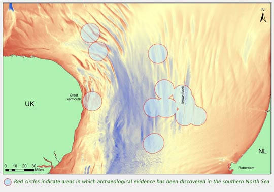
The Brown Bank Area of the Southern North Sea

Picture credit: University of Bradford
The picture above shows the location of the Brown Bank area, approximately sixty miles east of Great Yarmouth. The circles indicate areas in which archaeological evidence has been discovered in the southern North Sea.
Complimenting the “Lost Frontiers” Project
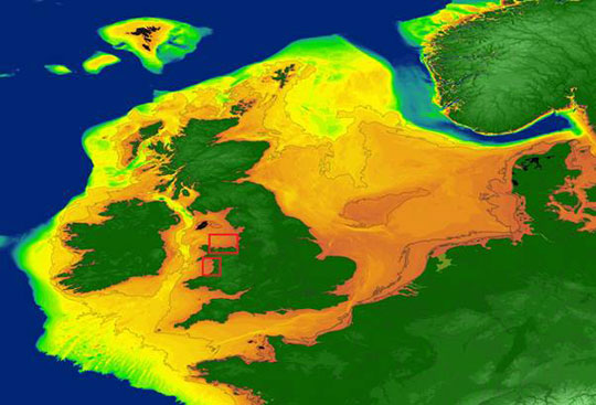
This two-year research project compliments the Bradford University-led “Lost Frontiers” project, in which archaeologists are mapping the ancient, prehistoric landscape of the North Sea known as Doggerland. The European Research Council (ERC) is funding the research. This area, now submerged, once connected the United Kingdom to Europe. As sea levels rose at the end of the last Ice Age between 8,000 to 10,000 years ago, so the land was gradually lost and all evidence of human settlement and activity was swallowed up by the rising waters.
Scientists working on the Lost Frontiers project have identified river valleys, hills, marshland and what were once great grassy plains stretching across thousands of square kilometres, but despite this, evidence of human activity has remained elusive.
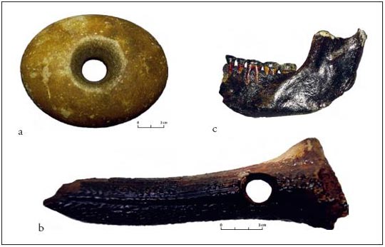
Evidence of Human Activity/Settlement from the Brown Bank Area

Picture credit: University of Bradford
A Home to Thousands of People
Chance finds by trawlers as they use drag fishing methods in the area have provided tantalising evidence of a hitherto hidden Stone Age world. Archaeologists have long suspected that this part of the North Sea may have been home to thousands of people, the aim of this new project is to prove that the Brown Bank area, an eighteen-mile-long (thirty kilometres), sand ridge, some sixty miles (one hundred kilometres), east of the Norfolk coast and around fifty miles (eighty kilometres), from Holland, was the location of a prehistoric settlement.
Commenting on the significance of this new research, Professor Vincent Gaffney (Bradford University), stated:
“If it is possible to undertake fieldwork that can locate prehistoric settlement on the Brown Bank this would be a major event. Until now the majority of Doggerland has been terra incognita in archaeological terms. If we can begin to locate settlement across the, currently, empty map of the Doggerland, we would open a new chapter in archaeological exploration.”
Professor Vincent Gaffney (University of Bradford)

Picture credit: University of Bradford
Ancient River Systems
The team hope to build on previous research carried out by Ghent University in which ancient river systems were plotted running across the southern North Sea area. Using this data, the researchers have pinpointed one particular area in the Brown Bank where there might have once been a large lake. If this area was home to a substantial human population, it is likely they would have built a settlement on the lake shore.
A member of the research team, Dr David Garcia Moreno (Ghent University), explained:
“Confirmation of the location of a prehistoric lake near the Brown Bank and the characterisation of the fluvial system associated with it would be a breakthrough. Such a discovery would have vast implications in our understanding of the palaeogeographic evolution of north-western Europe since the last Ice Age.”
A Map Showing the Approximate Maximum Land Area That Once Joined the UK and Ireland to the rest of Europe

Picture credit: University of Bradford
Help from the Belgian Navy to Find a Prehistoric Settlement
The project’s first phase will involve teams from the UK and Belgium surveying the target area with the assistance of the Belgian research vessel RV Belgica. This fifty-metre-long vessel will be home to the researchers whilst they build up a detailed map of the physical features of the seafloor. This survey will help them identify promising areas for further examination in part two of the project.
In the second phase, the team will extract sediment cores from these targets and analyse them to determine the environment of the landscape underlying the Brown Bank and to understand its potential for human settlement prior to its flooding.
Dr Tine Missiaen (VLIZ), stated:
“Submerged landscapes and human settlement in the North Sea did not stop at borders. International collaboration is indispensable to unravel this unique episode in Europe’s prehistory. Only the integrated use of novel state-of-the-art techniques will allow us to map and reconstruct these drowned landscapes and settlements with unprecedented detail.”
Everything Dinosaur acknowledges the assistance of a media release from the University of Bradford in the compilation of this article.
Visit the Everything Dinosaur website: Everything Dinosaur.


Leave A Comment