Scotland’s Mid Jurassic Heritage
The Isle of Skye is a beautiful island off Scotland’s rugged west coast, approximately 640 square miles of idyllic Scottish scenery, an island known for its Scottish heritage and tourism, so what does it have to do with the state of Wyoming in the American mid-west. The answer Jurassic dinosaurs.
Jurassic Dinosaurs
Well for a start, both places are sparsely populated and both areas have spectacular scenery and surprisingly the Isle of Skye has evidence of prehistoric animals that once roamed across the western USA. The data gathered on this Scottish island’s dinosaurs is helping to provide information regarding the Jurassic fauna of Wyoming, in fact Skye is fast becoming recognised as a place of great interest to palaeontologists. The same types of dinosaur roamed across Skye and Wyoming approximately 170 million years ago (Bajocian faunal stage), in a geological period known as the mid-Jurassic – but how is this possible?
During the Jurassic the American and European continents were very much closer together than they are today. There was no Atlantic ocean (this did not begin to form until towards the end of the Jurassic period), a series of rifts began to open up in the continental plates, separating the giant continent of Laurentia into the Americas and Eurasia. However, that part of the world that was eventually to form the rocks in areas like Staffin Bay on the Isle of Skye was still joined to the North American continent. A dinosaur could have walked from central Europe to Alaska had it had the mind to do so.
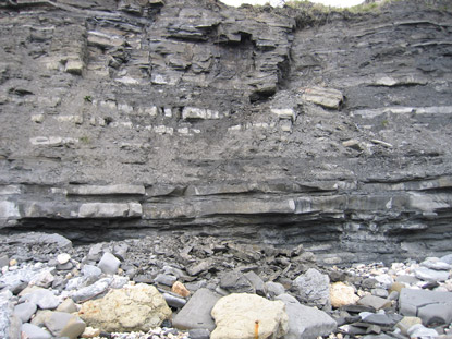
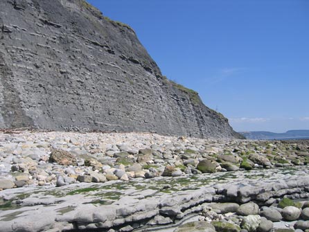
The Isle of Skye
The Isle of Skye’s importance to palaeontologists, particularly those studying the Middle Jurassic is enhanced by an article published in the current issue of the Scottish Journal of Geology. The article suggests that fossil footprints found on Skye and others across the Atlantic in Wyoming were left by the same type of dinosaur – or at least a closely related species – dating back to the mid-Jurassic period, when Scotland and the United States were both part of the same landmass.
The authors of this study into the fossil trackways, Dr Neil Clark, the curator of palaeontology at Glasgow University’s Hunterian Museum, and Dr Michael Brett-Surman of the Smithsonian Institution in Washington DC, state that the tracks found in rock formations in Wyoming’s Bighorn Basin are very similar to footprints found in the Valtos sandstone beds on the Isle of Skye.
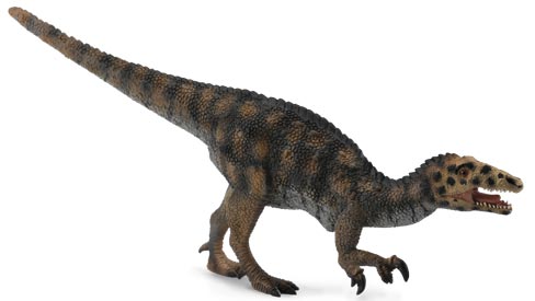
The footprints have been classified as having been made by a Coelophysid, an agile Theropod dinosaur. Coelophysids were the most common type of meat-eating dinosaur in the Late Triassic and survived into the Jurassic before finally being replaced by new types of theropod such as the megalosaurs.
An Illustration of a Coelophysid (Coelophysis)
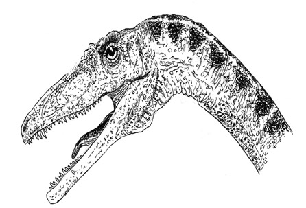
Picture credit: Everything Dinosaur
The illustration above shows a typical coelophysid, theropod, with its long neck, slender jaws lined with sharp, needle-like teeth. The best-known of these dinosaurs is Coelophysis, a Triassic carnivore with its slender, muscular body, hollow bones (Coelophysis means “hollow form”) and long legs. A number of articulated skeletons of this dinosaur are known, mostly recovered from the famous Ghost Ranch site in New Mexico.
Commenting on the link between Wyoming and the Isle of Skye, Dr Clark stated:
“The importance of this apparent link between Skye and Wyoming is that the Americans don’t actually have any dinosaur remains, apart from these footprints, from this particular period, the mid-Jurassic, whereas we have the bones of a number of different animals from that period here in Scotland. So, basically, we’re enabling the Americans to see what sort of dinosaurs were probably roaming about North America at the same time”.
He added:
“The Americans do have the animal called Coelophysis, but their fossils of them are all from the Lower Jurassic or Upper Triassic periods, so they are a lot older than what we have in Skye, which is a representative of that group of dinosaurs which was still alive in the Middle Jurassic. It seems to be associated with a particular type of footprint which also occurs in Wyoming at that particular time, so it’s quite possible they have a similar animal.”
While the footprints remain America’s only mid-Jurassic traces of the creature, Skye’s fossil beds from the same period have revealed a tooth and a tail bone, as well as the footprints. Although most associated with the Ghost Ranch discoveries, it seems that the Isle of Skye can claim to have important evidence too, regarding the evolution of meat-eating dinosaurs.
A Rare Glimpse into Prehistoric Life
The island has afforded palaeontologists other rare glimpses into prehistoric life, footprints of a large ornithopod dinosaur were discovered in the 1980s along with more evidence of coelophysid dinosaurs (fossil bones) and a fragment of bone that is believed to have come from a sauropod (long-necked dinosaur).
Whilst the rock formations in the mid-western USA are vast and have a wealth of fossil information, the finds on Isle of Skye are somewhat limited, although this does not diminish their scientific importance. The island’s Jurassic strata is overlaid by igneous material and the palaeontologists have only a few exposures to explore. They are situated in places such as the exposed Trotternish peninsula where the rocks are weathered by harsh winds and strong tides. It is often a battle with nature to find and preserve specimens before weathering destroys them for ever.
A Typical Sauropod of the Jurassic
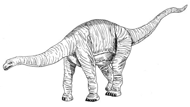
An illustration of a typical sauropod from the Middle Jurassic (Cetiosaurus). Picture credit: Everything Dinosaur.
Picture credit: Everything Dinosaur
The Isle of Skye may be a wild and rugged place, but it can hold its head up high when it comes to Jurassic dinosaur fossils, helping the likes of Wyoming to piece together its own ancient past. Not bad considering that Wyoming is much more associated with dinosaurs than Scotland, after all, the state dinosaur (yes, they do have a state dinosaur), of Wyoming is Triceratops.
Everything Dinosaur stocks a huge range of dinosaur and prehistoric animal models including replicas of many Jurassic dinosaurs: Models of Jurassic Dinosaurs.